


Between August and October 2026, Chinese carriers planned eight container sailings from Ningbo to the British port of Felixstowe across the top of Russia, according to Rosatom chief executive Alexei Likhachev, who spoke to Interfax on September 1. A year earlier the first transit voyage of this kind, from China to Europe, had taken 20 days, roughly half the time of the usual route through the Suez Canal. Rosatom expects cargo on the route to grow by about 14% in 2026, another record.
The same summer, Danish Shipping, the trade association of Danish shipowners, published its own reading of the numbers: the record 2025 season equaled roughly a day and a half of traffic around the Cape of Good Hope. Both statements are accurate. The Northern Sea Route (NSR) is growing fast from a very small base, and how it works, who may use it and when explains most of the gap between the two views.
This guide covers the legal boundaries of the route, the navigation season, the permit and ice-class rules, how icebreaker escort works and what the time savings really look like. Data as of October 2026.
What is the Northern Sea Route?
The Northern Sea Route is the shipping lane along Russia’s Arctic coast, from the Kara Sea in the west to the Bering Strait in the east. Rosatom, which Russia appointed as the route’s infrastructure operator, gives its length as about 5,600 km, or roughly 3,000 nautical miles by our conversion. It is the Russian section of the longer Northeast Passage between the Atlantic and the Pacific.
Its legal borders are set in the Rules of Navigation in the Water Area of the Northern Sea Route, approved by Russian Government Decree No. 1487 of September 18, 2020. For reporting purposes the western border runs through the Kara Gate, Matochkin Shar and Yugorsky Shar straits and along the meridian of 68°35′ E; the eastern border is the parallel of 66°05′ N and the meridian of 168°58′37″ W at the Bering Strait. Inside these lines the route is divided into 28 districts, each with its own ice conditions.
Most traffic on the route is domestic: supply runs to Arctic settlements and, above all, exports from Russian Arctic projects such as oil and liquefied natural gas. In 2025 total cargo on the route reached a record 37.02 million metric tons, according to Rosatom. Transit cargo, the voyages that start and end outside the route, made up only 3.2 million tons of that, also a record.
How long is the Northern Sea Route season?
For ordinary commercial ships the calendar is short. The Rules allow ships without an ice class, or with the lightest ice classes, to sail independently only between July 1 and November 15, and only in light ice conditions in most districts. In practice the transit season is shorter still: in 2025 the first transit ship entered the route on June 30 and the last left it on November 17, a window of about four and a half months, according to the Centre for High North Logistics (CHNL), an independent research center at Nord University in Norway.
For voyage planning between Asia and Europe, the academic reference Port Economics, Management and Policy describes the route as usable roughly from July to September. That matches what carriers do: the 2026 Ningbo to Felixstowe sailings were scheduled for August to October, the period of the least ice.
Outside that window, sea ice covers most of the route, and only ships with the highest ice classes can operate, usually behind an icebreaker. That is why much of the winter traffic consists of Russian Arctic LNG carriers and tankers built with the highest ice classes.
Who can sail the route: permits and ice classes
Every ship needs a permit before it enters the water area of the route. The Rules give the process in some detail:
- The shipowner, its representative or the master applies electronically to the Federal Agency of Maritime and River Transport, in Russian or English.
- The application goes in no earlier than 120 calendar days and no later than 15 working days before the planned entry date.
- The agency has 10 working days to decide, in agreement with the Marine Operations Headquarters set up by Rosatom, which has five working days to respond.
- A permit is valid for up to 365 calendar days.
- Once on the route, the ship reports to the Headquarters before crossing the border and then daily while it sails.
The permit is tied to the ship’s ice class, which describes how strong its hull and propulsion are against ice. The Rules contain a matrix that crosses ice class, district, season and ice conditions and says whether a ship may sail alone, only with an icebreaker or not at all. Ships with the lightest classes are limited to the summer and autumn window; ships with the strong Russian Arc7 class and above are allowed to sail independently in most districts and conditions for much of the year.
For a container line, this means an ordinary ship can be used only in the high season and only with planning months ahead. Our explainer on China and the Northern Sea Route looks at which Chinese carriers have done this and what ships they use.
How does icebreaker escort work?

Illustration: Portolan
When ice is too heavy for a cargo ship to sail alone, an icebreaker goes first and opens a channel. The cargo ship follows in the broken ice at a set distance; in difficult conditions the icebreaker may tow it closely or lead a small convoy of several ships. The Marine Operations Headquarters assigns the escort and sets its conditions, and escort is a paid service.
The heavy lifting is done by Atomflot, a Rosatom company that describes its fleet as the world’s only fleet of nuclear-powered icebreakers. As of March 2026 it had eight in service: Taymyr and Vaygach, built for shallow river mouths; Yamal and 50 Let Pobedy; and four ships of the newer Project 22220 class, Arktika, Sibir, Ural and Yakutia. According to Rosatom, these icebreakers can break ice up to about three meters thick, and the newest reactors can run for up to seven years without refueling.
More are under construction: three further Project 22220 ships, Chukotka, Leningrad and Stalingrad, each rated at 60 MW and Rossiya, the lead ship of a new class rated at 120 MW. We explain how a nuclear icebreaker is built and run in our guide to nuclear icebreakers.
“Very limited relevance to international shipping today and for the foreseeable future.” Jacob K. Clasen, Deputy CEO of Danish Shipping, on the Northern Sea Route, 2026
How much time does the Arctic route save?

Diagram: Portolan, based on Port Economics, Management and Policy, 2025
Distance is the route’s main selling point. From Shanghai to Rotterdam a ship sailing via the Suez Canal covers about 10,600 nautical miles and, at a steady 16 knots without port calls, needs about 27 days. Around the Cape of Good Hope the distance grows to about 13,800 nautical miles and the trip to about 35 days. The Northern Sea Route cuts the voyage to about 20 days, according to Port Economics, Management and Policy, and Rosatom gives the same 20 days for the first China to Europe transit in October 2025.
| Route, Shanghai to Rotterdam | Distance | Sailing time at 16 knots | When available |
|---|---|---|---|
| Via Suez Canal | 10,600 nm (about 19,600 km) | about 27 days | all year |
| Via Cape of Good Hope | 13,800 nm (about 25,600 km) | about 35 days | all year |
| Via Northern Sea Route | not given | about 20 days | about July to September |
Source: Port Economics, Management and Policy (Notteboom, Pallis, Rodrigue), data as of July 2025; kilometers converted by Portolan
Time saved at sea is only part of the bill. A transit ship needs an ice-class hull, which typically costs more to build and burns more fuel; it may pay for icebreaker escort; it sails slower in ice than in open water; and its insurers price in the Arctic risk. Carriers also cannot offer a weekly service when the route is open for three to four months a year. In our view, the route makes most sense for cargo that already moves between Russian and Chinese ports, or for single voyages timed to the season, and least sense for a regular liner service.
The long detours around Africa during the Red Sea crisis added to interest in Arctic routing. We compare all the options side by side, including rail, in our article on China to Europe shipping routes.
Who actually uses the route today
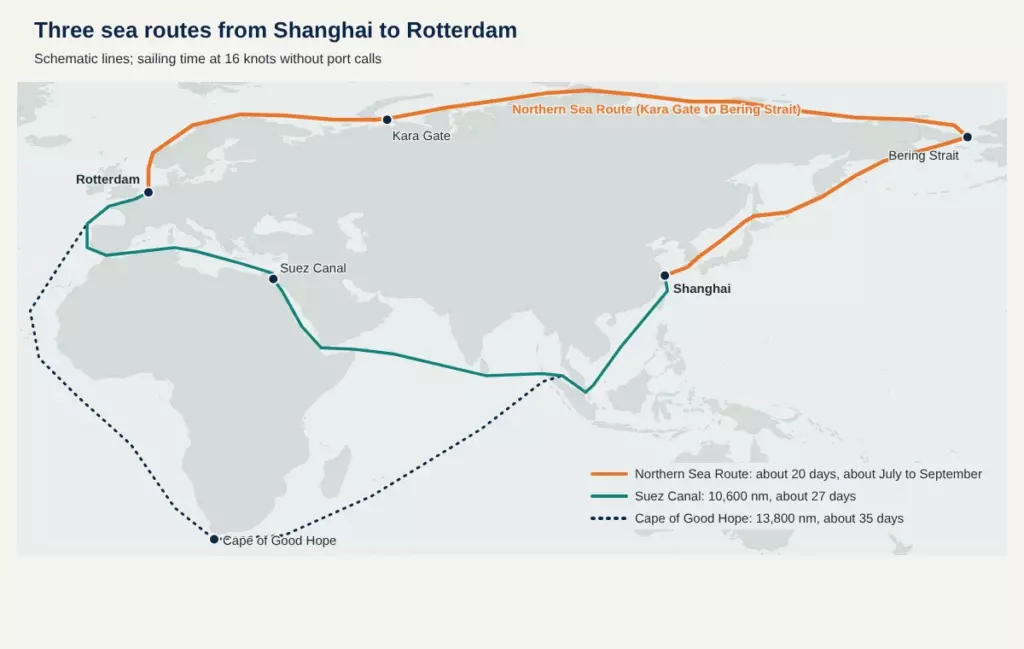
Diagram: Portolan, based on Natural Earth and Port Economics, Management and Policy, 2026. Routes are schematic
CHNL counts every transit voyage. In the 2025 season it recorded 103 of them, 52 eastbound and 51 westbound, made by 88 different ships, about 6% more than in 2024. Tankers and bulk carriers made up more than half of the voyages, and almost all of them sailed to or from Russian and Chinese ports.
| Ship type | Transit voyages, 2025 | Eastbound | Westbound |
|---|---|---|---|
| Tankers | 34 | 23 | 11 |
| Bulk carriers | 23 | 7 | 16 |
| Container ships | 15 | 8 | 7 |
| General cargo | 12 | 2 | 10 |
| Fishing vessels | 7 | 4 | 3 |
| LNG carriers | 5 | 3 | 2 |
| Reefers | 3 | 2 | 1 |
| Other | 4 | 3 | 1 |
| Total | 103 | 52 | 51 |
Source: Centre for High North Logistics, “Main results of NSR transit navigation in 2025”, data as of November 2025
The two sides read container traffic differently. Rosatom reported a record 400,000 tons of container cargo in transit in 2025; CHNL’s own estimate was about 287,000 tons. Rosatom also counts 23 container voyages between Chinese and Russian ports in 2025, a figure that includes voyages ending in Russian ports, and says Chinese carriers plan more than 30 in 2026. Cargo between Chinese and Russian ports reached 5.4 million tons, nearly 15% of all cargo on the route.
The Danish Shipping view is a matter of scale. More than 2,000 deep-sea cargo ships pass the Cape of Good Hope every month, so a record season of 103 transits remains a niche. Both sets of numbers can be true at once: growth is real, and so is the gap.
Will the Arctic become a main trade lane?
The physical case keeps improving: the route is shorter and the icebreaker fleet is growing. Rosatom plans for steady growth, and for Chinese shippers the route offers an alternative to the Strait of Malacca and the Suez Canal.
The constraints are just as concrete. The season lasts a few months, the permit regime is run by one country, insurers price the risk, and much of the world’s shipping fleet has no ice class. For Europe and the United States the route raises questions of trade, security and environment at the same time, which we explore in our article on what the Northern Sea Route means for Europe and the United States.
So the question for the next decade is narrower than it looks: will the Northern Sea Route stay a seasonal route for Russia and China, or will carriers from other countries start building ships and schedules around it?

